

‘Dam’-nation Without Relief
By Ali Bhutto | Newsbeat National | Published 6 years ago
Between the Surjano and Sumbak ridges of the Kirthar Range lies a pass referred to by locals as ‘dar’ (door) and ‘vaat’ (mouth). It has, as a result, taken on the name Darvaat. The pass, 310 feet wide, is one of the natural gateways from which hill torrents enter the plains in Sindh Kohistan.
The names of the two hills that form the pass, Surjano and Sumbak, are of particular significance. ‘Sur’ in Sindhi means pain while ‘surjano,’ according to Muhammad Urs Palari, a local of Thatta district, means pain-inducing. Sumbak, the other hill, is named after the grave of Sumbak Sawaee, which is located in its vicinity. According to Sindhologist and historian Badar Abro, Sawaee was most likely a local administrator and tax collector of the Kalhoras. The mythology surrounding him, he explains, is that he is the provider of prosperity – vegetation and pasture in particular.
The point at which pain and prosperity meet is also, by a strange symbiosis, one where relief comes from the heavens in the form of a torrential stream. Sindh Kohistan is a land of contrasts and contradictions, much like the rest of the province.
Darvaat Pass lies at the border of Jamshoro and Thatta districts, about ten miles east of Thano Bula Khan. It serves as a bottleneck through which rainwater from the Kirthar Hills flows southward via Nai Baran – a torrential wash – entering the Indus south of Kotri. The water that accumulates in Nai Baran can come from as far northwest as Kambhu Jabal – another subsidiary of the Kirthar – and Tikko Baran, a distant wash that lies beyond the Kirthar Range.
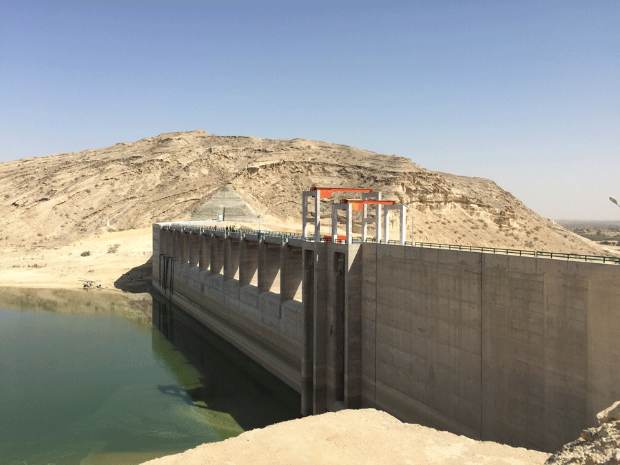
Darawat Dam (above) and its main irrigation outlet (below) in the command area. (Photos by the writer).
In the shadow of Surjano’s limestone ridge lies the village of Khuda Bakhsh Shoro, in Thatta taluka’s deh of Kohistan 7/1. A collection of approximately 10 straw huts, it is the village nearest to the pass and the home of Sher Muhammad Shoro, a veteran who claims to be 95 but whom locals believe is far older. Despite his age, Sher operates with the kind of agility common among the older denizens of the hills of Kohistan, most of whom commute long distances on foot in this remote, rugged region. “I have always lived here and seen little change,” says Sher. “But now, we have this monstrosity on our heads,” he adds, pointing at the dam that has been built in the pass. The exact word that Sher uses is “balaa” – Sindhi for monster.
Darawat Dam – a distortion of the term Darvaat – has remained dysfunctional ever since it was built, four-and-a-half years ago. Conceived by the Irrigation and Power Department of the Government of Sindh in 2007, its purpose is to enable villages in the region that rely on spate irrigation, to reap the maximum benefit from the hill torrent, a large portion of which otherwise went to waste. But the way things currently stand, it is providing no benefits – only deprivation.
A feasibility study was carried out by the Irrigation Department from 2007 to 2008 through National Development Consultants and Techno Consult International and upgraded the following year, with the help of Cameos Consultants and Spatsol Technologies. WAPDA was assigned the task of constructing the dam, its spillway and irrigation network, all of which were completed and ready for use by August 2014. This was Phase I of the project. Phase II, which involves the development of the command area – the area the dam will irrigate – is the responsibility of the Irrigation Department and has not yet begun. As a result, the entire project hangs in a state of limbo.
“People were getting water before the dam was built, but not now,” says Muhammad Idris Rajput, a former secretary of Sindh’s Irrigation and Power Department, who is currently a consultant for a project titled Revamping and Rehabilitation of the Irrigation and Drainage System in Sindh. He believes that while the dam is a good idea, the lack of an irrigation system in the command area has only created problems for locals. “WAPDA has completed its work,” he says. “Now, the Irrigation Department must develop canals.” However, he adds, “I don’t think they have a plan.”
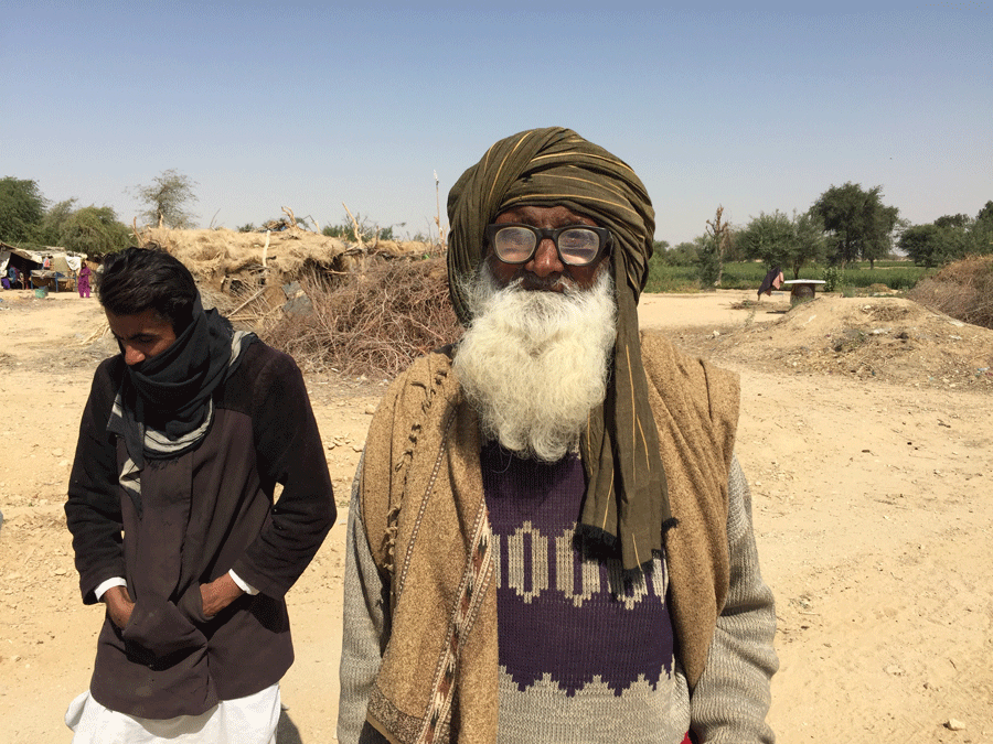
Sher Muhammad Shoro lives in the settlement nearest to the dam.
“Why is the Irrigation Department not developing the command area?” asks Naeem Arif, WAPDA’s General Manager, South. “Who will we give water to if there are no watercourses?” Darawat Dam is only one of several WAPDA projects that have not been properly utilised owing to a lack of development of their command areas. Balochistan’s Kachhi Canal (Phase I) has a command area of 72,000 acres of which only 10,000 acres have been developed, according to Arif. Similarly, the command area of Rainee Canal (Phase I), which originates from the Guddu Barrage, has not yet been developed, while large parts of the command area of Mirani Dam, in Balochistan, also remain undeveloped, he adds. “The problem lies in the irrigation departments of these provinces.”
Muhammad Aslam Ansari, Additional Secretary of the Irrigation and Power Department, Sindh, told Newsline that his department has not yet taken over the project from WAPDA due to a lack of funds. “The administrative funds aren’t there; the Finance Department has not yet released the SNE [Schedule of New Expenditure],” he says. The first step, according to him, is for the land in the command area to be allotted by the Board of Revenue. He says once that is done, “the landowners will develop the command area themselves and the irrigation department will give them compensation.” He adds that “the Board of Revenue has not allotted land possibly due to political reasons.”
Darawat Dam’s command area is 25,000 acres, all of which lies in Thatta taluka’s deh Kohistan 7/1. The deh, in turn, is divided into makans. The land in Thatta taluka is largely unsurveyed and dependent on rain.
In July 2013, the Supreme Court of Pakistan ordered the formation of a supervisory committee to scrutinise the reconstructed record of land ownership rights in various dehs across Sindh, where previous records had been damaged or destroyed. In February 2015, the committee submitted its findings on dehs in Thatta taluka.
On the basis of the report’s recommendations, the Sindh Board of Revenue issued a notification in April 2015 (available with Newsline), cancelling the reconstructed land ownership records of 58 dehs in Thatta taluka on the grounds that they contained “defects, omissions,” and “fraudulent entries through which government land has been mutated in the name of private persons.” Among these was deh Kohistan 7/1, which consists entirely of state land.
The notification summarises the report of the supervisory committee, citing that the reconstructed records of some of the dehs failed to mention the manner in which ownership had been acquired (whether by purchase, grant, or inheritance), that almost all entries lacked the authenticated documents required for ownership and that the new records contained far fewer entries compared to previous records. In the case of deh Kohistan 7/1 in particular, the notification highlights a curious development: ownership records had been reconstructed even though the previous record was available and had not been damaged. According to Palari, today, three years after the cancellation of these records, the situation is at a stalemate.
Darawat Dam is, on paper, a political selling point and is being advertised under the banner of women’s emancipation. Irrigated state land in the command area will be allotted to landless female residents in the deh, among others. “This will only be available to those who support the province’s ruling party,” contends Rajput, “and they are settled maybe a little further away from the dam.”
Prior to the dam, the villages near the pass had the privilege of being among the first to utilise the torrents of Nai Baran. Today, however, residents of Khuda Bakhsh Shoro, the village nearest to the dam, say they have no access to that water. “We pump water from tube wells for drinking purposes and to irrigate our wheat fields,” says Manthar Shoro. Neighbouring the village is a WAPDA colony where engineers and other employees were stationed while the dam was being constructed. It consists of air-conditioned bungalows, while the village, which has been there for generations, lacks electricity and any semblance of concrete, brick or even mud structures. And though it is all government-owned territory, Manthar insists that the colony was built on “our” land.
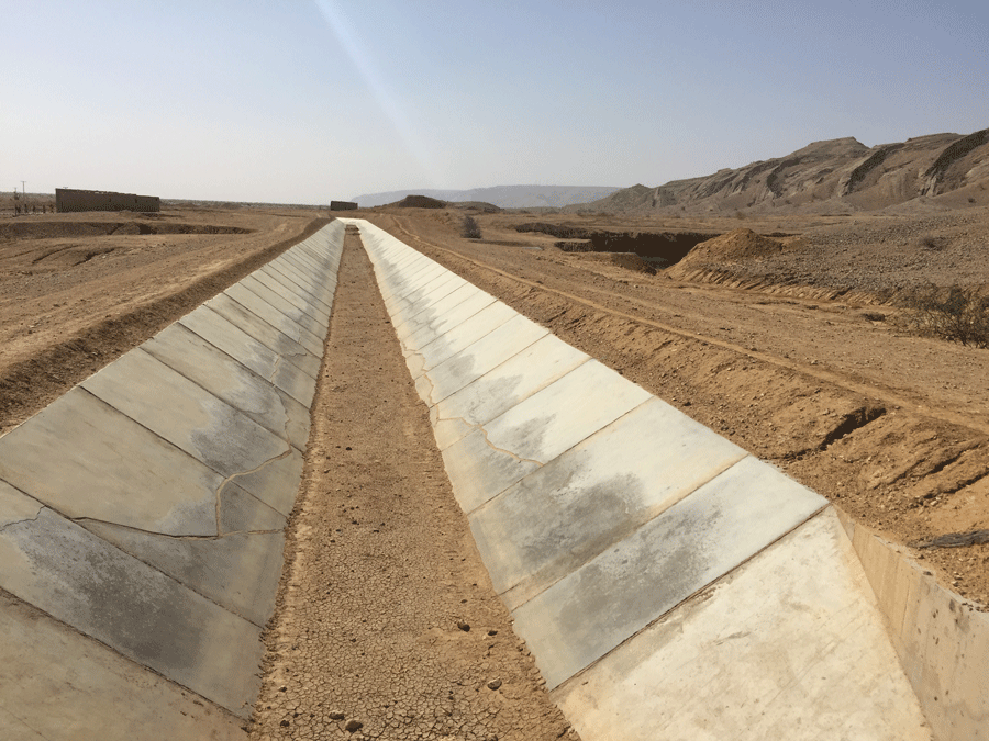
One of the dam’s canals built by WAPDA in Phase I of the project.
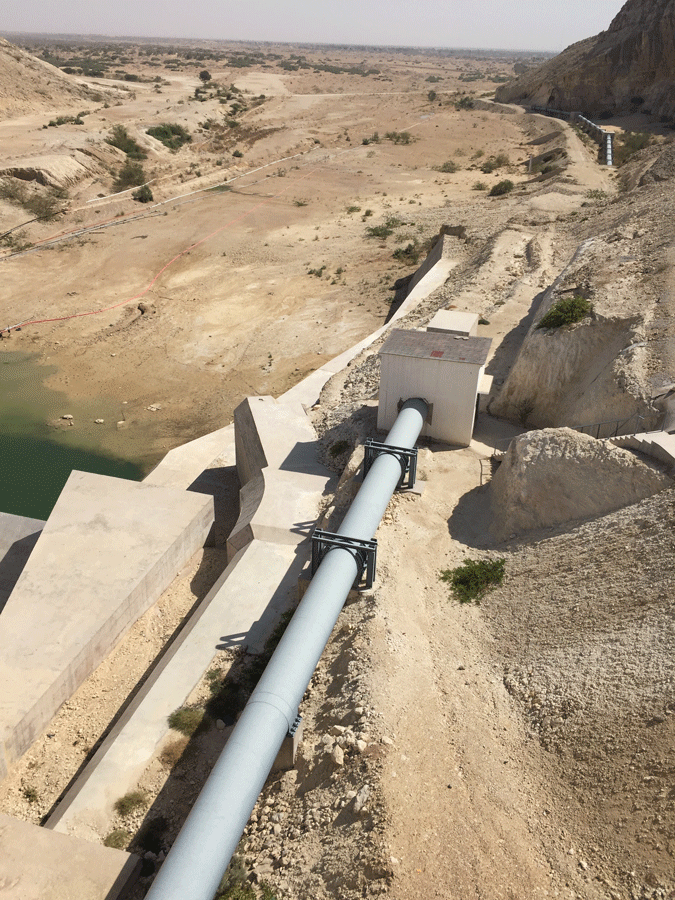
“Before the dam was constructed, the villages closest to the pass would naturally get water from Nai Baran,” says Naeem Arif, “and today too they have a right to that water.” On this basis, several small pipes, approximately two to three inches in diameter, can be seen extending from the dam and into the command area. According to Arif, their purpose is to supply water to villages such as Jhangri, which lie in the vicinity. “They pump water from the dam using these pipes.”
Phase I – the construction of the dam – has cost a total of Rs 11.8 billion (PC-1 cost), out of which Rs 2.1 billion have been allocated in the fiscal year 2018-19 under the Public Sector Development Programme (PSDP), for the purpose of clearing any outstanding liabilities. Of the allocated sum “we have received Rs 200 million,” says Arif. He explains that Darawat was cheaper than most other dams because the pass in which it is built is comparatively narrow.
“Before the dam was built, Nai Baran used to cultivate approximately 10,000 acres,” says Pir Zaman Shah Jeelani, a resident of Kotri whose family hails from Thano Bula Khan taluka. “The rainwater used to last the entire year, as the natural wells in the area would fill up,” he adds. “But now, with the dam holding back water, the wells have dried up. Thatta district does not receive any water from the dam.” Jeelani contends that the main problem is the dam’s height.
When I visited the dam in November 2017, the water level was significantly higher than on my second visit, in February 2019. Owing to rains in 2016, the water had reached a height of 108 metres, two metres higher than the dead-storage level of 106 metres, and could have been supplied downstream via the main irrigation outlet, in 2017, according to Arif. However, due to a lack of development in the command area, the water did not get very far. He says that command area development must always take place during the construction of the dam and not afterwards.
“After the dam was completed [in 2014], it took about two-and-a-half years for the water to reach a sufficient level,” says Lutfullah Shaikh, who was project director of the dam during Phase I. “Once it did, we supplied water both upstream and downstream from July to September 2017.” He adds, however, that it takes time for a rain-fed dam to fill up, especially when there is insufficient rainfall. According to Lutfullah, before the dam was built, a large quantity of the rainwater used to go to waste, flowing straight into the river; he says that now at least it will collect in the dam instead.
In January 2019, the water level recorded in the dam was 101 metres, well below the minimum dead-storage requirement. The maximum height the water must reach before spilling over is 112.5 metres. And while the dam has a gross storage capacity of 121,625 AF (acre-feet), the live storage – water that can actually be utilised for irrigation and drinking purposes – explains Arif, is 89,000 AF, with a power-generation capacity of 0.30 MW.
A network of canals, structurally more sophisticated than those usually found in Sindh, is visible from the metalled road that leads to the dam. They are as dry as the desert that surrounds them. Developed by WAPDA in Phase I of the project, they consist of the main off-taking canal and 63 outlets. The total length of this irrigation network is 46 kilometres.
“To date, the dam has not reached maximum capacity due to insufficient rainfall,” says Zahid Shaikh, the Irrigation Department’s Chief Engineer of Small Dams. Shaikh is slated to be the chief engineer of Darawat (a medium-sized dam), once the Irrigation Department takes charge of the project. This, he says, is expected to happen by June 2019, after the creation of an Irrigation Division, the employees of which will be trained by the engineers of Mangla and Tarbela dams in March 2019. “All issues will be resolved then,” he adds.
The writer is a staffer at Newsline Magazine. His website is at: www.alibhutto.com